


Size of Tent Pads: 12x12 10x10
Distance to Office/Boat Landing: 3 Miles to office, ½ mile to Bemis boat lunch
GPS Coordinates: 44 56'57.6"N
70 48'36.8"W
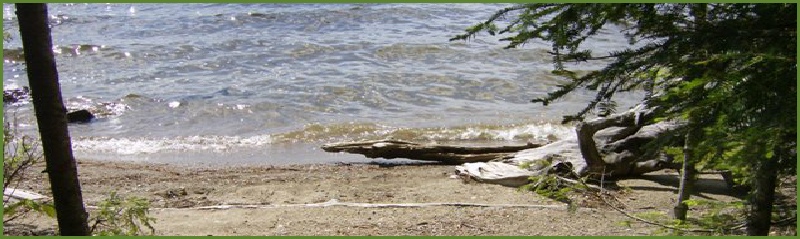
Shoreline: Large sandy areas
Boat Access: Deep water with no rocks
Description: This site provides views of the Bemis Range, the southern shore of Mooselookmeguntic and all day sun. This site is well protected from the wind and has easy access from the Bemis boat launch. The sandy beach is ideal for swimming and landing a boat. Although this site shares an outhouse with Toothaker 2, the sites are separated by more than 250 feet.
Toothaker Island
-9.JPG)
-8.JPG)
.JPG)
-7.JPG)
-6.JPG)
-3.JPG)
-8.JPG)
-1.JPG)
-10.JPG)
-9.JPG)
-9.JPG)

-10.JPG)
-9.JPG)
-10.JPG)

-11.JPG)
-10.JPG)
-11.JPG)

-4.JPG)
-2.JPG)
-11.JPG)
-7.JPG) Return to Campsites
Return to Campsites
Return to Campsites
Return to Campsites
Return to Campsites
Return to Campsites
Return to Campsites
Return to Campsites
Return to Campsites
Return to Campsites
Return to Campsites
Return to Campsites
Size of Tent Pads: 12x12 10x10 8x8 4x8
Distance to Office/Boat Landing: 3 Miles to office, ½ mile to Bemis boat lunch
GPS Coordinates: 44 51'52.6"N
70 47'04.2"W
Shoreline: Large sandy area 50 feet from site, rocky on site front
Boat Access: Deep water with no rocks at sandy area, rocky in front of site
Description: This site provides views of the Bemis Range, the southern shore of Mooselookmeguntic and all day sun. This site is well protected from the wind and has easy access from the Bemis boat launch. The sandy beach is ideal for swimming and landing a boat and is easily accessed by a short path. Although this site shares an outhouse with Toothaker 1, the sites are separated by more than 250 feet.
Size of Tent Pads: 12x12 10x10 8x8
Distance to Office/Boat Landing: 2 ½ Miles to office, 1 mile to Bemis boat lunch
GPS Coordinates: 44 52'09.7"N
70 47'23.3"W
Shoreline: Pebbles and small stones with some sand
Boat Access: Easy landing on small stones, watch for submerged rocks on the way in; land on either side of the large stump beached in front of the site.
Description: This site provides privacy, excellent views and a remote location. The site has views to the south and northwest. Strong northwest winds can blow directly onto the site, so bring a tarp as a windbreak. During low water a stone jetty provides protection for boats. The only disadvantage to this site is a long walk to the outhouse.
Size of Tent Pads: 12x12 10x10 8x8
Distance to Office/Boat Landing: 2 Miles to office, 1 ½ mile to Bemis boat lunch
GPS Coordinates: 44 52'24.4"N
70 47'32.5"W
Shoreline: Large rocks in front; with pebble beach on right side of site
Boat Access: Canoe landing only! Watch for submerged rocks and land at left or right of site.
Description: This site is nicely shaded. There is a nice flat area for your tents. Exploring on the rocks that jet out on this point would be fun. The site provides views of the north and west. There is a “wet willie” outhouse on this site, used only by campers on this site.
Size of Tent Pads: 12x14 2-8x8
Distance to Office/Boat Landing: 1 ½ Miles to office, 2 ¼ miles to Bemis boat lunch
GPS Coordinates: 44 52'37.8"N
70 47'18.9"W
Shoreline: Small sandy beach with submerged rocks
Boat Access: Small boat or canoe (15 horse or smaller); easy landing on left side of beach. Watch out for submerged rocks.
Description: This is a remote site with a small sandy beach. Water is very shallow and recommended for canoes only. The site is set back behind a small row of trees giving privacy and protection from the wind. This site is quite open and shaded. It has a large tent pad set in the back overlooking the site. Site has views of the eastern shore and the south end of Students Island.
Size of Tent Pads: 2-8x8 10x10
Distance to Office/Boat Landing: 1 ½ Miles to office, 2 ½ miles to Bemis boat lunch
GPS Coordinates: 44 52'37.7"N
70 47'11.0"W
Shoreline: Steep bank with high water, small beach with low water and deep pool good for swimming.
Boat Access: Easy access for most boats; some submerged rocks
Description: This remote small cove has great views of the north. This site has a pebbly shore that drops off very deep making it great for boat access. The entire site set up on a hill allowing for great views thru out. This site has views of the eastern shore and the south end of Students Island. This site has a private “wet willie” outhouse.